- Home
- Knowledge Base
- India
- States and Union Territories
- Uttar Pradesh
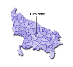
Uttar Pradesh
| Official Name | Uttar Pradesh |
|---|---|
| Administration of Uttar Pradesh | |
| Status | State |
| Statehood / Establishment Date | 26 January 1950 |
| Zone | Northern |
| Capital | Lucknow |
| Districts (or Administrative Regions) | 75 |
| Government Website | up.gov.in |
| Demography of Uttar Pradesh | |
| Largest Cities | Lucknow, Kanpur, Ghaziabad, Agra and Meerut |
| Population as per 2011 Census | 199,812,341 [Decadal Growth = 20.2% (from 2001 - 2011)] |
| Population Density | 828 persons / km2 |
| Official Languages | Hindi |
| Other Languages | Urdu |
| Sex Ratio as per 2011 Census | 908 ♂ / 1000 ♀ |
| Literacy Rate as per 2011 Census | 67.7% Male = 77.3% and Female = 57.2% |
| Geography of Uttar Pradesh | |
| Total Area | 243,286 km2 |
| Neighbouring States | Uttar Pradesh touches the borders of Delhi, Uttarakhand, Himachal Pradesh, Haryana, Rajasthan, Madhya Pradesh, Chhattisgarh, Jharkhand, Bihar (total 9 states/UTs). |
| Neighbouring Countries | Border of Uttar Pradesh also touches the international border of Nepal (total 1 countries). |
| International Border Length | 651 km |
| Coastal Border Length | Uttar Pradesh is not a coastal state/UT. |
| State Symbols of Uttar Pradesh | |
| State Animal | Swamp deer (Rucervus duvaucelii) |
| State Bird | Sarus crane (Grus antigone) |
| State Tree | Ashoka (Saraca asoca) |
| State Flower | Palash (Butea monosperma) |
| Codes for Uttar Pradesh | |
| ISO-3166-2-IN Code | IN-UP |
| Vehicle Code | UP |