- Home
- Knowledge Base
- India
- States and Union Territories
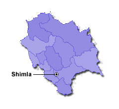
- Himachal Pradesh
Himachal Pradesh
| Official Name | Himachal Pradesh |
|---|---|
| Administration of Himachal Pradesh | |
| Status | State |
| Statehood / Establishment Date | 25 January 1971 |
| Zone | Northern |
| Capital | Shimla (Summer), Dharamshala (Winter) |
| Districts (or Administrative Regions) | 12 |
| Government Website | himachal.gov.in |
| Demography of Himachal Pradesh | |
| Largest Cities | Shimla |
| Population as per 2011 Census | 6,864,602 [Decadal Growth = 12.9% (from 2001 - 2011)] |
| Population Density | 123 persons / km2 |
| Official Languages | Hindi |
| Other Languages | English and Pahari |
| Sex Ratio as per 2011 Census | 974 ♂ / 1000 ♀ |
| Literacy Rate as per 2011 Census | 82.8% Male = 89.5% and Female = 75.9% |
| Geography of Himachal Pradesh | |
| Total Area | 55,673 km2 |
| Neighbouring States | Himachal Pradesh touches the borders of Jammu, Kashmir, Uttarakhand, Uttar Pradesh, Haryana, Punjab (total 6 states/UTs). |
| Neighbouring Countries | Border of Himachal Pradesh also touches the international border of China (total 1 countries). |
| International Border Length | 345 km |
| Coastal Border Length | Himachal Pradesh is not a coastal state/UT. |
| State Symbols of Himachal Pradesh | |
| State Animal | Snow leopard (Uncia uncia or Panthera uncia) |
| State Bird | Western tragopan (Tragopan melanocephalus) |
| State Tree | Deodar (Cedrus deodara) |
| State Flower | Pink rhododendron (Rhododendron campanulatum) |
| Codes for Himachal Pradesh | |
| ISO-3166-2-IN Code | IN-HP |
| Vehicle Code | HP |