Chhattisgarh
| Official Name | Chhattisgarh |
|---|---|
| Administration of Chhattisgarh | |
| Status | State |
| Statehood / Establishment Date | 1 November 2000 |
| Zone | Northern |
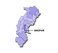
| Capital | Naya Raipur |
| Districts (or Administrative Regions) | 28 |
| Government Website | cgstate.gov.in |
| Demography of Chhattisgarh | |
| Largest Cities | Raipur, Bhilai Nagar, Korba, Bilaspur and Durg |
| Population as per 2011 Census | 25,545,198 [Decadal Growth = 22.6% (from 2001 - 2011)] |
| Population Density | 189 persons / km2 |
| Official Languages | Hindi |
| Other Languages | Chhattisgarhi |
| Sex Ratio as per 2011 Census | 991 ♂ / 1000 ♀ |
| Literacy Rate as per 2011 Census | 70.3% Male = 80.3% and Female = 60.2% |
| Geography of Chhattisgarh | |
| Total Area | 135,194 km2 |
| Neighbouring States | Chhattisgarh touches the borders of Madhya Pradesh, Uttar Pradesh, Jharkhand, Odisha, Andhra Pradesh, Telangana, Maharashtra (total 7 states/UTs). |
| Neighbouring Countries | Chhattisgarh does not share its border with any other country. |
| International Border Length | 0 km |
| Coastal Border Length | Chhattisgarh is not a coastal state/UT. |
| State Symbols of Chhattisgarh | |
| State Animal | Wild water buffalo (Bubalus bubalis arnee) |
| State Bird | Bastar hill myna (Gracula religiosa peninsularis) |
| State Tree | Sal (Shorea robusta) |
| State Flower | Lady's Slipper (Rhynchostylis gigantea) |
| Codes for Chhattisgarh | |
| ISO-3166-2-IN Code | IN-CT |
| Vehicle Code | CG |