- Home
- Knowledge Base
- India
- States and Union Territories
- Arunachal Pradesh
Arunachal Pradesh
| Official Name | Arunachal Pradesh |
|---|---|
| Administration of Arunachal Pradesh | |
| Status | State |
| Statehood / Establishment Date | 20 February 1987 |
| Zone | North-Eastern |
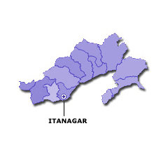
| Capital | Itanagar |
| Districts (or Administrative Regions) | 25 |
| Government Website | arunachalpradesh.gov.in |
| Demography of Arunachal Pradesh | |
| Largest Cities | Itanagar |
| Population as per 2011 Census | 1,383,727 [Decadal Growth = 26.0% (from 2001 - 2011)] |
| Population Density | 17 persons / km2 |
| Official Languages | English |
| Other Languages | Monpa, Miji, Aka, Sherdukpen, Nyishi, Apatani, Tagin, Hill Miri, Adi, Digaru-Mismi, Idu-Mishmi, Khamti, Miju-Mishmi, Nocte, Tangsa and Wancho. |
| Sex Ratio as per 2011 Census | 920 ♂ / 1000 ♀ |
| Literacy Rate as per 2011 Census | 65.4% Male = 72.6% and Female = 57.7% |
| Geography of Arunachal Pradesh | |
| Total Area | 83,743 km2 |
| Neighbouring States | Arunachal Pradesh touches the borders of Assam, Nagaland (total 2 states/UTs). |
| Neighbouring Countries | Border of Arunachal Pradesh also touches the international border of China, Bhutan, Myanmar (total 3 countries). |
| International Border Length | 1817 km |
| Coastal Border Length | Arunachal Pradesh is not a coastal state/UT. |
| State Symbols of Arunachal Pradesh | |
| State Animal | Mithun (Bos frontalis) |
| State Bird | Great hornbill (Buceros bicornis) |
| State Tree | Hollong (Dipterocarpus macrocarpus) |
| State Flower | Lady's Slipper (Cypripedioideae,) |
| Codes for Arunachal Pradesh | |
| ISO-3166-2-IN Code | IN-AR |
| Vehicle Code | AR |