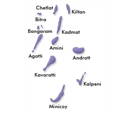
Lakshadweep
| Official Name | Lakshadweep |
|---|---|
| Administration of Lakshadweep | |
| Status | Union Territory |
| Statehood / Establishment Date | |
| Zone | Arabian Sea |
| Capital | Kavaratti |
| Districts (or Administrative Regions) | 1 |
| Government Website | lakshadweep.gov.in |
| Demography of Lakshadweep | |
| Largest Cities | Kavaratti |
| Population as per 2011 Census | 64,473 [Decadal Growth = 6.3% (from 2001 - 2011)] |
| Population Density | 2,013 persons / km2 |
| Official Languages | Malayalam |
| Other Languages | English |
| Sex Ratio as per 2011 Census | 946 ♂ / 1000 ♀ |
| Literacy Rate as per 2011 Census | 91.8% Male = 95.6% and Female = 87.9% |
| Geography of Lakshadweep | |
| Total Area | 32 km2 |
| Neighbouring States | Lakshadweep touches the borders of (total 1 states/UTs). |
| Neighbouring Countries | Lakshadweep does not share its border with any other country. |
| International Border Length | 0 km |
| Coastal Border Length | The total length of coast line of Lakshadweep is 132 km |
| State Symbols of Lakshadweep | |
| State Animal | Butterfly fish (Chaetodon decussatus) |
| State Bird | Sooty tern (Onychoprion fuscatus) |
| State Tree | Bread fruit (Artocarpus altilis) |
| State Flower | Neelakurinji (Strobilanthes kunthiana) |
| Codes for Lakshadweep | |
| ISO-3166-2-IN Code | IN-LD |
| Vehicle Code | LD |