- Home
- Knowledge Base
- India
- States and Union Territories
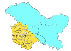
- Jammu and Kashmir
Jammu and Kashmir
| Official Name | Jammu and Kashmir |
|---|---|
| Administration of Jammu and Kashmir | |
| Status | Union Territory |
| Statehood / Establishment Date | 31 October 2019 |
| Zone | Northern |
| Capital | Srinagar (Summer), Jammu (Winter) |
| Districts (or Administrative Regions) | 22 |
| Government Website | jk.gov.in |
| Demography of Jammu and Kashmir | |
| Largest Cities | Srinagar, Jammu and Anantnag |
| Population as per 2011 Census | 12,541,302 [Decadal Growth = 23.6% (from 2001 - 2011)] |
| Population Density | 290 persons / km2 |
| Official Languages | Hindi and Urdu |
| Other Languages | Dogri and Kashmiri |
| Sex Ratio as per 2011 Census | 883 ♂ / 1000 ♀ |
| Literacy Rate as per 2011 Census | 67.2% Male = 76.8% and Female = 56.4% |
| Geography of Jammu and Kashmir | |
| Total Area | 163,090 km2 |
| Neighbouring States | Jammu and Kashmir touches the borders of (total 1 states/UTs). |
| Neighbouring Countries | Border of Jammu and Kashmir also touches the international border of Pakistan, China, Afghanistan (total 3 countries). |
| International Border Length | 3176 km |
| Coastal Border Length | Jammu and Kashmir is not a coastal state/UT. |
| State Symbols of Jammu and Kashmir | |
| State Animal | Not declared yet (Not declared yet) |
| State Bird | Not declared yet (Not declared yet) |
| State Tree | Not Designated (Not Designated) |
| State Flower | Common rhododendron (Rhododendron ponticum) |
| Codes for Jammu and Kashmir | |
| ISO-3166-2-IN Code | IN-JK |
| Vehicle Code | JK |